What Happened to US Highway 66's Spur Routes?
While the history of Route 66 is extremely well documented, both by myself and other transportation historians and bloggers, its child routes don't often get the same amount of attention. Of course, none of these routes had anywhere near the impact of 66 on our culture, but I think each one has a bit of interesting discussions about them to blog about.
US Route 66 had seven spur routes from 166 to 666, with two different 366's in existence at different points in history, although none of these roads' legacies came close to that of its parent, with the possible exception of the infamous Devil's Highway, which necessitated a numbering change to US-491 in 2003. While Route 66 itself has a fairly bloody and dark history that isn't as discussed as much in nostalgia, so too does a few of its spur routes.
 |
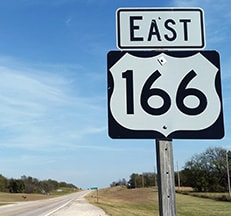
| EB US-166 assurance shield. Alex Nitzman photo. |
The poor engineering and high speeds of US-666 were the actual catalysts of the fate of the Devil's Highway, and as the road has been improved over time, the severity of crashes has decline.
Since US-666 was renumbered, only two of 66's spur routes exist today, 166 and 266, which are obviously orphaned since 66's decommissioning. That leaves the two 366s, 466, and 566 to discuss. To briefly summarize the existing 166 and 266, US 166 runs for about 163 Miles between South Haven, KS and I-44 west of Joplin, MO, running in the state of Missouri for less than a mile, while multiplexed with another US Route, US 400. Were it truncated to where it connects with US 400, it would lay entirely within Kansas. US 266 is an even stranger case, as it is just 43 miles in length, and only runs between US-64 in Warner, OK and US-62 in Henryetta, OK, going under I-40, US 66's replacement, without even an interchange. Beginning service in 1926, this replaced OK-9. How this route survived for as long as it did is beyond me, although I think it's unlikely to be decommissioned now, given its association with 66.
There were actually two US-366's, one from El Paso, TX and Amarillo, TX (which despite beginning and ending in Texas was mostly located in New Mexico), and another from Albuquerque to Willard, NM. The former route was an original US Highway, existing from 1927-1931, while the latter lasted only slightly longer, from 1932-1939.
The first 366 was replaced with US-54, US-380, US-70 and US-60 between El Paso and Amarillo.
 |
| A 1933 NMDOT map showing US-366 in the Roswell Area. University of Alabama maps collection. |
The second US-366 also ran in New Mexico along a much shorter route, essentially along today's present-day I-40 and NM-41 from Albuquerque east to Moriarty, and then from Moriarty south to Willard, NM. This replaced another original US Highway, US-470, and would last until 1939. US 66 was eventually re-routed to the Moriarty-Albuquerque segment, leaving only the north-south alignment of 366, which only lasted a couple years.
 |
| David Rumsey Map Collection: 1937 New Mexico Highway Map |
US Highway 466 existed between 1935-1971 between Morro Bay, CA (at CA-1), and US-66 at Kingman, AZ. Unfortunately, it has quite a sad history, and quite visibly so. On September 30, 1955, Hollywood actor James Dean passed away in a fatal car accident, at the corner of what was then US Highway 466 (present day CA-46) and CA-41, near Cholame, CA.
 | |
| A replica of the car and of the intersection where the crash occurred at the Hollywood Star Cars Museum in Gatlinburg, TN (FRRandP photo, July 2023). |
The junction between the two roads is now memorialized in his name. Sadly, just weeks before the accident, Dean filmed a thirty second commercial for the National Highway Safety Committee, telling drivers to "take it easy driving. The life you might save might be mine."
 |
| David Rumsey Map Collection: 1950 California State Highway Map |
Finally, US-566 was only around for five years between 1926 and 1931. Originally a spur from US-366 at Hondo, NM, it connected 366 to US-85 at San Antonio, NM. It was replaced in its entirety by US-380 in 1931, which it still remains to this day.
 |
| David Rumsey Map Collection: 1931 New Mexico Highway Map |
Thanks as always for reading!


Comments
Post a Comment