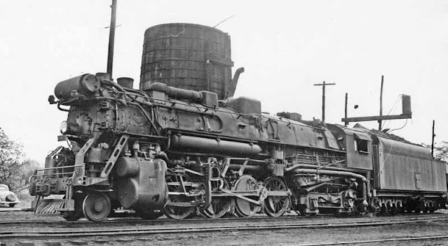
The Tennessee Alabama & Georgia Railway, often simplified as the TAG Route, which also was its reporting mark, was a short line railroad running from Chattanooga, TN southwest to Gadsden, AL for a distance of roughly 90 miles.
The railroad began operations in 1891 under the name of the Chattanooga Southern Railway, nicknamed the Pigeon Mountain Route, as it followed the area of Pigeon Mountain, which was the basis for its freight haul - namely coal, timber and iron.
An 1892 map shows that the ultimate plan of the road was to extend southwesterly from Gadsden to Birmingham, but this never came to fruition for the company - although the two cities were already connected by rail via Attalla, AL.
 |
"Map showing the proposed Tennessee, Alabama, and Georgia Railroad connecting and extending the Chattanooga Southern Railway, Marietta and North Georgia Railway, Knoxville, Cumberland Gap and Louisville Railroad, and Morristown and Cumberland Gap Railroad." (Library of Congress)
|
Proposals for extensions south of Gadsden were likely derailed partly due to the
Panic of 1893, which would cause a depression lasting until 1897 - and impacting the profitability of railroads across the United States, including the Chattanooga Southern. A common practice in those days during reorganization and/or bankruptcy was to change the name of the company to a railway from a railroad, or vice versa. Such was the case in 1896, as the Chattanooga Southern Railway became the Chattanooga Southern Railroad.
This is the name the company would hold for the next fifteen years until 1911, when another reorganization changed the name of the line to the Tennessee Alabama & Georgia Railway - the name the route would hold for the majority of its life.
Both World Wars would result in an uptick in railroad abandonments across the United States, especially World War II, as steel was in relatively short supply. A third, and the largest, period of abandonment would begin in the early 1970's, especially in the Northeastern United States, and yet the TAG Route, despite its initial financial woes, would find itself as one of the few short lines that would survive all three of these periods as an independent operator - and a profitable one at that.
The railroad was instrumental in transporting steel between Gadsden and Chattanooga, as both Republic Steel and the
Siskin Steel Company would utilize the line for shipments of raw materials and the finished product. This success from such a relatively small company would come to the attention of its larger competitors, especially the
Southern Railway, who saw the line as taking carloads away from their business.
In 1971, the Southern Railway would purchase the line, and would begin the process of dismantling it, although not immediately. Starting in the 1980's, the line would begin to be abandoned in piecemeal sections, as is typical. Southern Railway's successor, the
Norfolk Southern Railway, would continue to abandon sections of the road until about 2010, when most of the line had been abandoned, save for some industrial operations in/around the Chattanooga area.
While that's the history of the line, at least what I could confirm, the abandonment of the TAG Route holds an interesting spot in the history of the abandoned railroad map project and this site itself, as it was the first time I had ever realized that abandoned rights of way could be traced on satellite imagery.
The first job that I got in the mapping industry had me view imagery in the northwestern corner of Georgia on Thanksgiving of 2014, and with little in the way of activity as a result of the holiday, I found myself able to partake in a pastime I love; looking at the world through Google Maps and Google Street View, especially of old, semi-abandoned railroad crossings. While I wouldn't have considered myself a railfan at the time, I've always found the rare movements, rare mileage, and small branch lines and spurs to be far more interesting in the railroad world than the large trunk lines that are so often what are discussed and photographed, if for nothing else than the novelty of seeing a train in a rare location.
As such, I found the remnants of the TAG, although I had no idea what railroad it was at the time, quite fascinating.
 |
| Google Street View image of Woburn Rd, Georgia, along the former TAG right of way, with the rails still intact - albeit disused for many years. |
I got to a point where the rails were no longer visible on satellite imagery, but were visible on Street View. And from there, I got to a point where the rails were either dismantled or completely covered by brush - but I could make out the right of way on satellite imagery. Yet I could easily tell that a railroad had run there at some point I hadn't known it at the time, but I had begun tracing abandoned railroad rights of way.
Eventually, I came to a body of water, and was able to locate bridge piers indicating the line continued further south still.
I never forgot about the fun I had tracing this line, but I knew that I wanted to keep a repository of all my tracings somewhere, although I knew that there must be plenty of abandoned railroads (although I had no idea just how many), so I initially strayed away from continuing to trace lines on a map, as I really had no idea of where to begin.
But 18 months later in March of 2016, I began the project one line at a time, and nearly 10,000 lines later, I have the Tennessee Alabama & Georgia Railway to thank for getting things started!
Further Reading:
A History of Georgia Railroads by Robert C. Jones (
Amazon)
Thanks as always for reading, and have a safe and happy Thanksgiving!


Comments
Post a Comment