Posts

Showing posts from September, 2021

Interstate 97: Why it Exists and How to Remove It

Image
I am not a fan of I-97; the number, not the road itself. The road itself is a short but important connection between Baltimore and Annapolis, MD, but it exists as only a 17 mile freeway, shorter than most three digit interstates. In fact, it is by far the shortest primary interstate highway, that is, one with only two digits in its numbering, and while I-87 in North Carolina (sadly) exists; it is planned to connect to Norfolk, VA, along a corridor longer than 100 miles in length.  That numbering will almost certainly be an entire blog of its own, but today we're going to explore how I-97 came into being as the short connector route that it is today, and how it could be incorporated into a much longer route.  A state-named Northbound I-97 Mile Marker. Famartin, Wikipedia Commons  - 2018. I propose five alternatives in renumbering, although I'm certain none will be acted upon, it's been a fun exercise for road enthusiasts to fix issues with the Interstate Highway System, such

The Telegraph Rd Behind Dire Straits' "Telegraph Road"

Image
"And the dirty ole' track...was the Telegraph Road"...the first time I heard those lyrics, I knew I was listening to one of the most incredible songs I'd ever heard. To find out it was based on an actual  Telegraph Rd was just the icing on the cake. Before the creation of Interstate 75, The major thoroughfare between Toledo and Detroit was Telegraph Road . Currently carrying US Highway 24, Telegraph Road was immortalized as a song by Dire Straits in their 1982 album "Love Over Gold".  Early travel brochure for US-24, showing its importance as a road one could use between Los Angeles and Quebec; although it only ran from Michigan to Colorado. If you have 14 minutes to spare, the song is an awesome bit of 80's progressive rock. Today we're going to do things slightly different, in that I was to discuss the history of both the road and the song, because I think the lyrics do a great job to that end. The modern-day Telegraph Road is one of the major par

A Railroad into the Clouds: The Mount Washington Cog Railway

Image
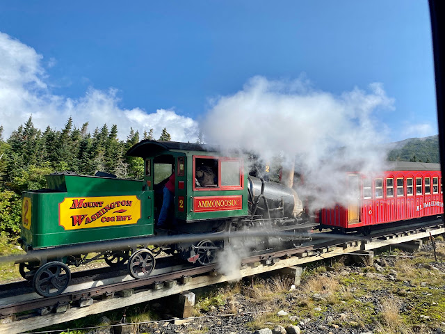
A New Hampshire state legislator in the 1850's suggested that Sylvester Marsh, who was planning a railroad line from the base to the summit of Mount Washington, New Hampshire, should be granted the charter; not just to the summit, but to the moon as well, for how impossible such a railroad line would be. At over 6,200 feet in height, Mount Washington is the tallest mountain in the Northeastern United States, and its summit is well above the tree line, making the ascent feel similar to the much higher mountain terrains in the Rocky Mountains. Despite the incredible prominence of the mountain, Marsh was undeterred, and even put $5000 of his own money towards the project, which helped secure the charter for the railroad. In 1868, Marsh would prove his detractors wrong when his railroad was completed, one of the first rack and pinion railways in the world, and to this day the second-steepest grade in existence. This line is the Mount Washington Cog Railway , which we visited during La

Railbike Explorers: Railbiking Rhode Island!

Image
Last week, we visited another railbike excursion, this time the RailExplorers: Rhode Island Division . We initially were scheduled to go on the northern tour, but with flooding wreaking havoc on the entire Northeast after remnants of Ida passed through, we were moved onto the southern tour.  Just like with our visit to Tracks and Yaks in Frostburg, MD, we had an incredible time biking and taking in the scenery of southeastern Rhode Island! Luckily, by the time we'd visited, there were nothing but sunny skies and perfect weather, which certainly made filming our experience easier! The railbike tour uses remnants of the former Old Colony & Newport Railroad  line, which once linked Newport to Fall River, MA and points north, such as Boston. Through the product of numerous mergers and acquisitions, like many railroad companies, it would eventually become part of the much larger New York New Haven & Hartford  Railroad. Like the rest of the New Haven, this became part of Penn Ce

Cleveland's Abandoned Pedestrian Bridge: The Sidaway Bridge

Image
The Sidaway Bridge was a pedestrian bridge built over the Kingsbury Run that connected two otherwise unconnected neighborhoods in Cleveland, OH; namely the Kinsman Road and Jackowo neighborhoods. Despite its length at 680 feet, it was built solely for use as a pedestrian bridge. In fact, it is the only suspension bridge in the Cleveland area. While it still stands today, it has been closed for over fifty years. (Location on our Abandoned Places map) Image via the Cleveland Historical Society . " Spanning Kingsbury Run: This 1966 photo, with a view generally to the north, shows the full length of the Sidaway Bridge. It is 680 feet long with a center span of 400 feet. Its 6-foot wide walkway is located 80 feet above Kingsbury Run. The bridge's two support towers are 105 feet tall. One writer noted in 1978 that, while it won no awards when it was built, it is clearly a beautiful structure. Also shown in the photo are the buildings built by the Nickel Plate Railroad for use as c