Posts

Showing posts from August, 2021

US Highway 97 in Alaska

Image
The Territories of Puerto Rico, Alaska and Hawaii were included in the Federal Aid Highway Act of 1956 , with the latter two, Alaska and Hawaii preparing to become US states, which they would become in 1959.  As such, a question arose as to whether the US Route system could be expanded into these new future-states as well. While a US Highway that entered another state, or was over 300 miles in length would be impossible in Hawaii, it would be easily possible in the vastness that is Alaska, and thus a push was made to give the Alaska Highway the US-97 designation. US Highway 97 has been mostly the same since it was first designated 1934, running from Weed, CA in the south where it started at US-99, now Interstate 5, to the Canadian Border north of Oroville, WA.  But in trying to connect the future State of Alaska to the Lower 48 in a more concise way, the idea of a northerly extension to US-97 gained serious traction, to the point where signs were actually created for the highway. Th

The Abandoned Railroad Map of Washington State

Image
As we've done for the States of Illinois , Rhode Island and Florida , we've completed a static map of Abandoned and Out of Service Railroad Lines based on the abandonments, railbanked corridors, and out-of-service lines in the State of Washington. Abandoned/Out-of-Service Railroad Corridors in Washington State, 2021. FRRandP creation in QGIS using Mapbox Streets v10 as a background and state/county lines from US Census data. Clicking on this image will bring up the map in its original size. This data was gathered by us over the last five years and is available on our Abandoned & Out of Service Railroad Lines Map , and where we had missing/incomplete data, we pulled data from the WSDOT GIS Data Catalog , who maintains a shapefile of railroads active and abandoned in the State. Neither ours nor WSDOT's data is completely encompassing however, as there are numerous logging railroads that have not been mapped, many of which have little/no traces left, similar to our map in

The New York & Brooklyn Bridge Railway

Image
The Brooklyn Bridge opened in 1883, predating the adoption of the automobile by several decades. As such, it was originally envisioned as a bridge to transport horse-drawn carriages, trains and trolleys. The latter of which was carried over the bridge until 1950.  Today, pedestrians, bikes and cars use the bridge, and it remains a major tourist attraction for the city.  "Bird's-Eye View of the Great New York and Brooklyn Bridge and Grand Display of Fire Works on Opening Night" (1883) The New York and Brooklyn Bridge Railway , a cable car service, began operations in 1883, shortly after the bridge itself opened. It ran on the inner lanes of the bridge, between terminals at the Manhattan and Brooklyn ends. Harper's Weekly, 10/12/1895, "The erection of a new terminal at the New York end of the Brooklyn Bridge is a task of far greater difficulty than the erection of the one on the Brooklyn side. In Brooklyn a new station was built directly across the street from the

Railroad And Roller Coaster: The Mauch Chunk Railway

Image
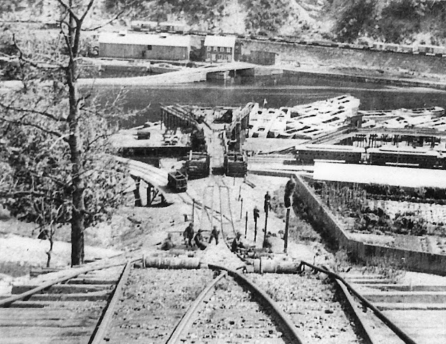
In 1828, state-of-the-art transportation technology would come to the Pennsylvania mountains in the form of the Mauch Chunk and Summit Railroad . It was built to transport coal from the top of the mountains to the canal below. It was not the first railroad in the United States, but it existed at a time when many railways were still experimental in nature, and the industry was taking baby steps into becoming the modern form of transportation of the day, and displacing the canal, which was still king. The story actually begins in 1792, when Anthracite coal was first discovered in the area. In attempting to bring the coal to Philadelphia markets, 100 miles away, Josiah White and Erskine Hazard purchased land at Mauch Chunk. "They built first a road, then a gravity railroad, to bring the coal down from Summit Hill to their new village of Mauch Chunk. Here shallow boats were loaded with 8 to 10 tons of coal. The boats went down the Lehigh through a series of low dams with gates that c

Kawanishi-Noseguchi, Kinunobebashi, Takiyama, Uguisunomori, Tsuzumigataki, Tada, Hirano, Ichinotorii, Uneno, Yamashita, Sasabe, Kofudai, Tokiwadai, Myokenguchi

Image
I suppose the title needs a bit of explanation. That is a list of stations on the Nose Electric Railway between Kawanishi and Yoshikawa regions of Japan. I'm a big fan of the   Metal Gear Solid series of video games, which if you are unfamiliar with, I could explain in the sense that they are military stealth games with a ton of Japanese influence, but that hardly explains the appeal of the games. Each of the underlying themes and characters within the games are ocean deep, to put it mildly, but there's an inherent silliness to the games as well. Numerous YouTube videos and personalities have dissected each game in an extreme level of depth, some of my favorites I will link to, but will spare you the trouble of doing so myself.  Nose Electric Railway 3170. Wikipedia Commons. So what does this have to do with the list of stations in the title? An Easter Egg  that consistently appears in the games (in fact, all with the exception of Metal Gear Solid 3 it appears, unless someo