Posts

Showing posts from August, 2020

The Milwaukee Road's River Division Abandonment

Image
Like roads, many railroad lines have been realigned and improved over time, and thus there are many examples of railroad abandonments that do not result in any loss of railroad service. Typing in "original alignment" onto our map will display all of the re-alignments we have found, although many more exist across North America. One example of this was the Milwaukee Road's River Division between Hastings, MN and Red Wing, MN. The original alignment of the road lay along the Vermilion River on swampy land, and was thus prone to flooding and track washouts. Image : "Red Wing's leading quarry owner G.A. Carlson built this 1882 Barn Bluff limestone kiln near the Milwaukee Road's tracks. He wished to facilitate shipments of lime and cement. The kiln, pictured about 1885, still exists." In 1908, this roughly 13 mile section of line was abandoned in favor of a straighter, more easterly grade on higher ground. The 13.1 mile original alignment in B...
The Richmond & Rappahannock River Railway

Image
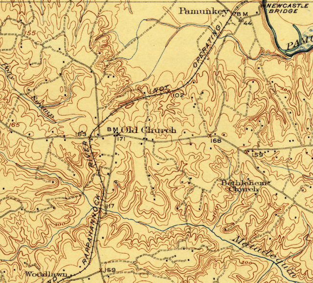
The Richmond & Rappahannock River Railway was chartered to run northeasterly from Richmond, VA to Tappahannock, VA in 1912. ( Right of way ) In service for just five years, the railway served little other purpose other than a cautionary tale against the phrase " If you build it, they will come ", as that isn't always grounded in reality. While this is a historical railroad that had the misfortune of being built right before World War I, there are numerous highway examples  which have done little to spur development . But I digress. USGS Historic Topo Map , King William, 1920. A 1915 newspaper article promoting the line advertised it, and its owner, the Richmond Land & Development Corporation in the following way:  "An illustration of the expansion of its industrial activities in Richmond and to territory beyond its corporate limits, is in the enterprise of the Rappahannock  Land and development Corporation, formed to open up a well located section. This featu...

The Medway Branch Railroad

Image
The Medway Branch Railroad was, as the name suggests, a short branch line from the Norfolk County Railroad at North Wrentham, MA (present-day Norfolk), running northwesterly toward Medway, MA, beginning in 1853. ( Right-of-Way ) The road offered passengers round trips between Medway to North Wrentham, where they could connect to Boston and points east. If a train wasn't running, passengers could traverse the route via a handcar. Passenger traffic did not sustain the line, and governmental funding did not come for the venture. In 1863, it came under the umbrella of the Boston Hartford & Erie, along with the Norfolk County Railroad. Just one year later, the line was abandoned, making it one of the earliest railroad abandonments in Massachusetts. Image : Boston Hartford & Erie Locomotive “Hooksett” [Medway Historical Society] Thanks as always for reading!

The Wild Mouse at Eagle Amusement Park

Image
Eagle Park was an amusement park located in Cache, OK, opening in 1957. It sat on land from an earlier amusement park known as Craterville Park. At its peak, it had numerous rides, shows, and events, and had ample campground land as well. The signature attraction was Wild Mouse, a roller coaster type of the same name . The park closed in 1985 amid rising insurance costs, and the owners not wishing to raise prices for entrance. Despite last operating in 1985, a few of the rides still stand today, most notably the Wild Mouse roller coaster. Image: Wild Mouse by Ricky Summersett, 2020. ( RCDB )

The Springfield & Illinois South Eastern Railway

Image
The Springfield and Illinois South Eastern Railway connected Springfield, Illinois' State Capital, to Shawneetown, IL on the Ohio River, a distance of about 175 miles. The company was formed in 1870 following a merger of two railroad companies: The Pana Springfield & North Western Railroad, and Illinois South Eastern Railway. Both a product of mergers and acquisitions, it would succumb to one just five years later, when it was acquired by the Ohio & Mississippi Railway.  For most of its life however, it would fall under the flag of the B&O Railroad, as subsidiary line the Baltimore and Ohio Southwestern Railroad. B&O 2917 Locomotive. Image via Southern Illinois Railroads The B&O combined the right of way with its own branch line from Springfield northwest to Beardstown, IL, creating a 220+ mile line.  The Line on an 1876 B&O Railroad Map. Image: Wikipedia Commons The line would slowly be abandoned throughout the latter part of ...

The Elham Valley Railway

Image
The Elham Valley Railway ran between Folkestone and Canterbury in the southeast United Kingdom. It was a product of competition between the South Eastern Railway and the London, Chatham & Dover Railway, as the two sought the railway traffic in the area. ( Right of Way ) Unknown photographer via Pinterest. Etchinghill Railway Tunnel along the former route. Built in 1887, it was just under 16 miles in length. As it ran primarily through rural areas throughout its life, it was never a successful operation. According to Chris Rosindale, "Much of it can still be seen and walked on its route through the Elham Valley. This is a line which really should never have been built, it owed its existence to a fierce rivalry between the South Eastern Railway and the London, Chatham and Dover Railway over access to the Channel ports. It was built by one of the two companies as a blocking action to stop the other company from invading its 'territory.' Barrie A.F. Clark'...

The Ohio River & Columbus Railway

Image
The Ohio River & Columbus Railway ran from Sardinia, OH to Ripley, OH on the Ohio River, a distance of 24.6 miles. It ran along steam power, but was planned for electrification, and held other properties more similar to interurban railways than a short line railroad. Nicknamed, the " Relief and Comfort ", it only operated for fourteen years. OR&C Right of Way south of Georgetown, OH. Image: USGS Higgins Topo Map, 1931 The route opened in 1903 along a similar route proposed earlier by the Columbus & Maysville Railroad, a predecessor railroad to the Norfolk & Western , with whom the OR&C interchanged with at Sardinia. Image: OR&C 4-6-0 Locomotive at Ripley, OH. Virginia Tech Archives. Heading southeasterly along the Ohio River, the railroad planned to extend to Aberdeen, as well as completely electrify their right of way, but neither of these initiatives were accomplished on account of financial hardships. While the line had more favorable f...

US Highway 112

Image
US Highway 112 originally connected Detroit, MI with Elkhart, IN, starting in 1926, along with the rest of the original US Highways.  In 1932, it moved farther west, connecting Detroit with Rolling Prairie, IN. In 1936, its final routing was established, running between New Buffalo, MI and Detroit, thus remaining entirely within Michigan. The Indiana portion of the ex-US-112 was briefly known as US-112S .  Michael Summa Simulated 112 Shield via USEnds The route ran south of its parent US-12, but along a similar route, as both roads ended in Detroit. The road had its origins as part of the Sauk Trail between Chicago and Detroit, and would be the primary method of connecting the two major cities, until the Interstate Highway System came into existence.  Entire Sauk Trail- From  Chicago’s highways, old and new, from Indian trail to motor road - 1923 As part of this, US 12 was upgraded to freeway standards beginning in the 1950's, in anticipation of becoming Interstat...