Posts

Showing posts from June, 2020

Ottoman Railway Ruins in Nitzana, Israel

Image
In 1917, during World War I, the British and the Ottoman Empire were engaged in battle in and around the Sinai and Gaza regions of present-day Egypt and Israel. At the center of the battle was an Ottoman Railway line running from Be'er Sheva to Hafir el Auja. ( Wikipedia ) The railway was being extended south and west from Hafir el Auja to the Suez Canal, making it a strategically important piece of infrastructure that would significantly increase the Ottomans' military capabilities in the region. As such, it was a target for the British and her allies. 13 Miles of the railway line were destroyed by troops from New Zealand on May 23rd, 1917, with more stretches destroyed the next day, in a significant victory for the British. ( Route on the Abandoned & Out-of-Service Railroad Lines Map) To this day, the only part of the railway that was rebuilt currently runs from Ramat Hovav to Be'er Sheva in Israel. Within present-day Egypt, the railway had been completed to an...

The Dodge City Montezuma & Trinidad Railway

Image
The Dodge City Montezuma & Trinidad Railway was a short lived railroad operating between Dodge City and Montezuma, KS. ( Right of Way ) Looking at a map today, you'll notice Dodge City and Montezuma are still connected by rail. However, the Montezuma that exists today was platted by the Atchison Topkea & Santa Fe Railway in 1912, almost two decades after the original Montezuma, KS would become a ghost town. Original alignment. This particular line ran slightly south of the current AT&SF alignment, beginning service around 1890. Its entire existence was the result of three towns vying for county seat of Gray County, KS. Ingalls and Cimarron were both located on another branch of the AT&SF; while Montezuma had no rail connection. In exchange for dropping their fight to become county seat, a railroad promoter promised to build a line to Montezuma. True to his word, Montezuma got a rail connection, but one that would last less than five years. The line was ab...

The Underwater Water Slide: Fly Over at Durinrell TikiBad

Image
Have you ever wished to experience being transferred from one pool of liquid to another via a pipe? Had you visited the Dutch water park known as Durinrell , also known as Tikibad before 2010, you would have had the chance. Half water slide, half war crime, this was a unique water slide that was filled to the brim with water, leaving riders completely submerged throughout the journey. Image:  XtremeRidesNL Known as the Fly Over was an underwater water slide, which is exactly how it sounds, and transported riders from one pool to another using the water as propulsion. Built in 1994, riders dove underwater to access the slide, using gravity to transport them upwards via the Communicating Vessels Principle . Riders would be completely underwater for about 15-20 seconds. This is how I imagine those 15-20 seconds felt like while riding the slide. The slide was built to drain water in five seconds or less in case a rider got stuck in the slide or had a medical emergency, but the threat...

Indiana's First Railroad: The Madison & Indianapolis Railroad

Image
The Madison and Indianapolis Railroad was the first chartered railroad in the state of Indiana, incorporated by the State in 1836 and operational in 1841 between Madison and Queensville. The next year, it was put into private hands, and by 1847, the full extent of the line was complete, connecting its namesake cities. Most of the line remains in existence, despite transferring hands many times. In 1866, it was reorganized as the Jeffersonville, Madison and Indianapolis Railroad , before later becoming part of the Pittsburgh Cincinnati, Chicago and St. Louis , and then being passed down as companies would merge into to the Pennsylvania Railroad, Penn Central, Conrail, CSX, and finally the short-line Madison Railroad . Somewhat ironically, given how much of the State of Indiana is quite flat, the most interesting part of the line was known as the Madison Incline , and it is now out-of-service. ( Right of way ) It covered a distance of 7,012 feet rising 412 feet in elevation to achieve a...

Goodbye, My Coney Island Railroad!

Image
The Prospect Park & Coney Island Railroad connected Brooklyn, NY with Coney Island , beginning in 1875. In that time, Brooklyn was independent from New York City, until it became a borough in 1898 . The line began at Greenwood Cemetery on its north end, using track on present-day McDonald Ave. From the cemetery, riders could transfer to horse drawn streetcars to connect to Downtown Brooklyn. Prospect Park & Coney Island Train On its south end, it ran the extent of Coney Island, ending at the north beach, until Surf Ave was extended in 1883, cutting about 500' off the line, the abandoned portion of which is viewable on our map of abandoned and out-of-service railroad lines . For a short time between 1895-1899 it was owned by the Long Island Railroad , who often scheduled trains to/from downtown Brooklyn from Coney Island. In 1899, the line switched from steam power to electricity. While most of the elevated right of way exists as today's Culver Line , run by the MTA, ...

The Mont Cenis Pass Railway

Image
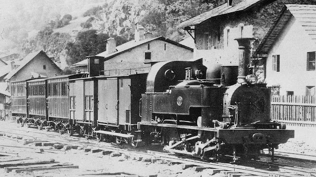
The Mont Cenis Pass Railway connected Modane, France and Susa, Italy, running over the Alps with operations beginning in 1868. Just three years later, the railway was abandoned when the Fréjus Rail Tunnel came online. ( Right of way ) In 1870, when the tunnel workers could hear one another from opposite sides of building camps, a telegraph was sent, reading, "The working parties in the opposite headings of the Mount Cenis Tunnel are within hearing distance of each other. Greetings and hurrahs were exchanged through the dividing width of rock for the first time at a quarter past four o'clock on Christmas afternoon." Mont Cenis Steam Engine and Train While the railway was always intended to be a temporary line until the tunnel was complete, construction on the tunnel was so rapid that the Pass Railway never recouped its investment and was a considerable loss for its investors. But its three rail design by John Barraclough Fell would become the standard for mountain railwa...

Great Northern's Rossport Branch: The Columbia & Red Mountain Railway

Image
The Columbia & Red Mountain Railway connected Northport, WA and Rossland, BC, Canada, with service beginning in 1897. At the time of its opening, its Northport Bridge was one of the first bridges over the Columbia River. Once the road was complete, the right of way became the Great Northern Railway 's Rossport Branch. ( Right of way ) Northport Bridge. Image via BridgeHunter While the route connected two countries, transported passengers, and crossed a major river, its primary economic driver was British Columbia's copper industry, and the railway helped transport the metal from Canadian mines into American markets. A train crossing the Northport Bridge . The prosperity would come to a screeching halt during World War I , when copper prices plummeted worldwide, causing the Rossville mines to close. Just three years later, Great Northern applied to abandon the line, receiving approval from both the US and Canada to do so in 1922. The right of way was converted into a high...

Underwater Twice a Day: The Passage du Gois

Image
The Passage du Gois is a road that connects the Island of Noirmoutier with mainland France. It is 2.5 miles long. What makes the road noteworthy is that it is flooded twice a day by high tide. It is only passable for a few hours each day during low tide, and many drivers have had to be rescued from the road due to flooding. ( Google Maps link ) Nonetheless, The Passage du Gois has a rich history and has been in use for centuries as a means of accessing the island. The Passage du Gois during a daily flood. The road itself is still in service, but has been practically replaced by the Pont du Noirmoutier (Noirmoutier Bridge) on the southern part of the island as a means to drive back and forth without having to worry about the tides. Still, it is a popular tourist destination, attracting visitors from all over the world who come to see the unique natural phenomenon and to explore the island. Visitors to the Passage du Gois can take guided tours of the causeway, explore the island, and ...

The AASHO Road Test: A Breakthrough in Pavement Technology

Image
The 1950's were an incredibly transformative time in American transportation, with the passing of the Federal Aid Highway Act of 1956. Driving on I-80 through Central Illinois, you will pass a sign that offers only a small clue of just how expansive this shift was, showcasing one of the many pieces of building our highways, the pavement itself. Perhaps you underestimate the amount of engineering and science that pavement materials go through, and this test is a great example of this in action, when the stakes were extremely high, as the largest road expansion in history was in its infancy. Starting in 1956, AASHO, the predecessor to today's AASHTO, began a $27 Million project tp study different pavement materials, and the impacts that traffic would have on those materials. Image: Google Street View The AASHO Road Test was instrumental in scientific breakthroughs on how pavements responded to traffic load, weights, climate impacts, and how long pavement would l...

The Tuskegee Railroad

Image
Despite being just under six miles in length, the Tuskegee Railroad served a vital purpose, in connecting Tuskegee, AL with the rest of the US rail network. It ran 5.7 miles north from Tuskegee to Chehaw, AL, where it connected to the Western Railway of Alabama . The road was completed in 1860, using slave labor in its construction. ( Right of way ) Tuskegee Railroad steam engine. Phil Kotheimer Collection It was a casualty of the Civil War in 1863, but would be rebuilt once again in 1872. The railroad declared bankruptcy several times, and reorganized, but unlike many other railroads, it kept its name in spite of reorganization. Originally narrow gauge, it was converted to standard-gauge in 1898. The railroad's main purpose in the 20th century was to facilitate traffic into Tuskegee Normal & Industrial Institute, which later became the Tuskegee University , a member of the Historically Black Colleges and Universities. By 1963, the railroad was no longer needed, and the build...

Prairie Ridge, Florida and the South Florida & Gulf Railroad

Image
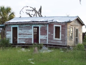
Prairie Ridge is a ghost town in south Florida, located in what is now Kissimmee Prairie Preserve State Park, first developed around 1910. ( Location ) Developers from the Midwest, known as the Southern Colonization Company, purchased a large tract of land in the area, believing the land would make excellent farmland. 10 acre lots were sold, in what was considered small farms at the time. A dilapidated shack inside the settlement, possibly the original railroad depot. Image: Jim Pike To further enhance the prospects of the town, the SCC commissioned the building of the South Florida and Gulf Railroad in 1915, which ran from Prairie Ridge to Kenansville on the Florida East Coast Railway, 29 miles north.  ( Right of way )  Connections south to Basinger and Okeechobee were planned, but never built. Trains ran along the route once a week to transport passengers, but it soon became apparent that the development of farmland was not going to be successful, as the land was more suite...