Posts

Showing posts from January, 2020

The Abandoned Capital City: Plymouth, Montserrat

Image
Plymouth is the capital city of Montserrat , an overseas territory of the United Kingdom. In 1997, it had a population of 4,000. (Location on our Ghost Towns Map ) Beginning in 1995, however, the Soufrière Hills volcano began erupting after centuries of dormancy.  After initially being allowed back, residents were evacuated when further eruptions created pyroclastic flows in the city, and the southern part of the island. Plymouth Disaster Zone:  Photo: Andrew Eames The southern part of the island continues to be in an exclusion zone as a result of the volcano, but residents have relocated on its north end. All government buildings have been relocated to Brades; but the capital city still officially remains as Plymouth, although the city is south of the exclusion zone, and thus completely uninhabitable. This makes it the only example of a ghost town which also serves as a capital city. A YouTube video on the disaster has been made from Half as Interesting

The Cassville & Western Railroad

Image
The Cassville and Western Railroad connected Cassville, MO with Exeter, MO along a five mile right of way. First proposed in January 1896, the line quickly secured financing, and construction along the short route was complete in June of that year. This gave Cassville a connection to the Frisco system at Exeter, connecting it to the rest of the US Railroad Network. Fields' Photo Archives via Barry County Museum . The line was imperative to Cassville's success, as roads to the town were impassable during the winter, and during inclement weather. By 1919, the line was nonetheless facing bankruptcy. After reorganization as the Cassville & Exeter Railroad, its fortunes changed dramatically. Fields' Photo Archives via Barry County Museum . It was billed as the shortest independent standard-gauge railroad, although there were quite a few examples of shorter short lines, such as the Illinois Midland Railway . Newspapers across the US, and Ripley's "Believe i

The Morehead & North Fork Railroad

Image
What would become the Morehead & North Fork Railroad in 1905 was first proposed as the Morehead & West Liberty Railroad in 1891. ( Right of way ) Image: Morehead State University Digital Archives. The M&WL built 4 out of a proposed 20 mile right of way between a junction with the Chesapeake & Ohio Railroad at Morehead, and Redwine, KY on the North Fork of the Licking River. The M&NF continued on to complete the road. It was almost entirely a logging railroad, but was a common carrier, and did haul clay after a decline in timber hauls. Significant curves and grades were a feature along the line. A major flood in 1929 would significantly hamper operations, with abandonment of all but the first 4 miles of track would be granted in 1933. Further Reading: " Steam in the Heart: Life and Times Along the Morehead and North Fork Rails "

The Mississippi River Hamburg & Western Railway

Image
The Mississippi River Hamburg & Western Railway connected Crossett, AR with Luna Landing, on the Old River, which itself is an older channel of the Mississippi River. In all, the route was just under 50 miles in length. ( Right of way ) Image: Bill Pollard Upon completion in 1901, the line became a subsidiary of the St. Louis Iron Mountain & Southern Railway , who became its outright operator in 1909. 1901 MRH&W Map via Bill Pollard The line's primary haul was lumber, but in an ironic twist, also hauled gravel for highway construction, which would be a contributing factor in rendering the line obsolete. A 1927 flood significantly damaged the road, of which the line could never recover from. Abandonment was approved with no objections in 1929. Thanks as always for reading!

Interstate 755: A Cancelled Urban Freeway

Image
Interstate 755 was a never built freeway proposal, which would have run through downtown St. Louis, MO, connecting I-44/I-55 at its south end, with I-70 on its north end. Image of the proposed freeway and nearby streets, turned horizontally via NextStL A downtown connector for the routes that run through St. Louis was first proposed in 1947, well before the Interstate Highway System would come to fruition. What a 755 shield would have looked like as an interstate highway. The road encountered both public opposition and funding issues, as attitudes towards urban freeways changed in the early 1970's, not just in St. Louis, but in many parts of the US . The road, had it been built, would have cut through established, historic neighborhoods, in addition to increasing taxes in the area. By the early 1980's, the economic downturn of the area would be end of the proposed highway. While the project was cancelled, ghost ramps from both the junction of I-44/I-55 and I-70, which would ha

The Partially-Built Ocean Shore Railroad (San Francisco to Santa Cruz, CA)

Image
The Ocean Shore Railroad was planned to connect San Francisco with Santa Cruz, CA, with construction beginning in 1905 at both ends of the route. Image and History Just one year later, the San Francisco Earthquake of 1906 occurred, and caused major damage to the route, and forced the line to become two separate projects; San Francisco-Tunitas Creek, and Santa Cruz to Swanton. Within San Francisco, the right of way was electrified, and portions of the route are still in service as part of the BART System. Outside of San Francisco, the right of way ran along the Pacific Ocean, paralleling the modern-day CA-1 (Pacific Coast Hwy). The Swanton line found partial use by a logging company, but by 1920, the San Francisco-Tunitas Creek line was abandoned, outside of portions of the route that were incorporated into Rapid Transit lines. Both the inability to connect San Francisco and Santa Cruz, and increased competition from automobiles and roads were contributing factors in the lin

The Craigville Gap

Image
Craigville , in far northern Minnesota, was the terminus for two rail lines which primarily handled lumber: the Minneapolis & Rainy River Railway , and the Minnesota Dakota & Western . The MD&W ran north to Littlefork, while the M&RRy ran south to Deer River; but the lines were separated by the Big Fork River. You really have to zoom into the map to see the gap! Requiring a less than 200' bridge to connect the lines, the MD&W purchased building materials to construct the bridge. However, the Great Depression would occur right around this time, significantly damaging both lines' profitability. The MD&W was never able to act upon connecting the lines, and the materials soon rotted. The M&RR would be abandoned shortly after in 1932. Today, very few buildings exist within Craigville, which once served as a hub for loggers along both rail lines. Thanks as always for reading!

Dr. Martin Luther King Jr. Drive in Chicago, IL

Image
Originally named Grand Blvd, and later S Park Avenue (or S Park Way), Dr. Martin Luther King Jr. Drive in Chicago, IL became the first street named after the civil-rights leader , following his assassination in 1968. The street runs along the south side of the city and is approximately 14 miles (22.5 km) long. MLK Drive is an important thoroughfare in Chicago, connecting the South Side with other parts of the city. The street is home to a diverse mix of communities, including residential neighborhoods, cultural and historical landmarks, and recreational areas. Image: Wendell Huston, DNAInfo Today there are over 700 streets named in his honor. Not every name change has been without controversy, however, as Kansas City, Missouri attempted to rename a historic street name, The Paseo, after MLK Jr., to which voters overwhelmingly objected . Interestingly, while a very common name for a street, there is no single way to describe the road, which can lead to some confusion between ci

New Caledonia's Nouméa-Païta Railway

Image
The island of New Caledonia in the Pacific Ocean is about 850 miles from mainland Australia, and has a population of roughly 270,000 people.  Despite its remoteness, it was once home to a railway, specifically the Nouméa-Païta Railway . Outside of some isolated and short industrial operations, this was the only railroad activity on the island. First opened in 1904 after several years of construction, it was intended to connect with Canala on the north end of the island, but would only be opened to a length of about 25 miles, ending a bit north of its implied end of Païta. An extension was then considered, but world events beyond the control of New Calendonia would prevent any further expansion of the line. Railway at Noumea, c.1905 Two World Wars, a plague, and the increased competition from the automobile industry would do the line in by 1940.  In 1942, the line was briefly reopened, as the American 790th Railway Transportation Company reopened the line to operate Allied presence in N

The Uintah Railway

Image
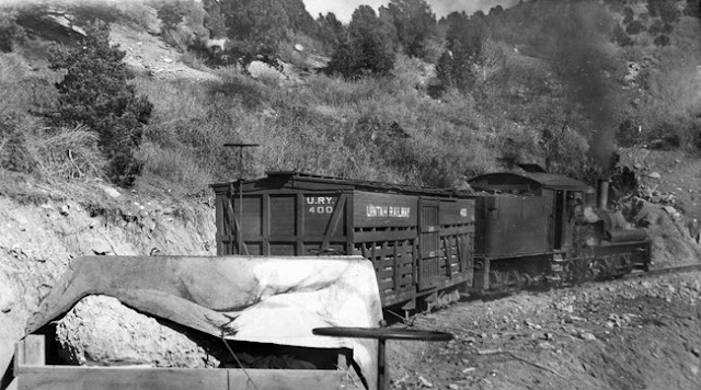
The Uintah Railway ran between Mack, CO and an area near Rainbow, UT for a distance of about 63 miles, beginning in 1904. ( Right-of-Way ) A narrow gauge operation, its primary haul came from Gilsonite , but also hauled passengers, cattle, mail and library books.  One of the more unique elements of the railway, in addition to its incredible curves, was its impact to the science and education. When a library opened up in Dragon, UT, the railway agreed to deliver and return books free of charge to anyone along the route. It also hauled dinosaur bones that were excavated from the gilsonite mines!  "The fossils were carefully prepared by Earl Douglass to make sure they weren’t damaged during the transport process. Never the less, the bones proved to be so heavy the wagons actually had to be lowered into a trench and the bones loaded directly onto them because they were too heavy to pick up. Even with this precaution, one of the specimens broke through the bottom of one of the wagons

Newfoundland Railway's Trinity Loop

Image
The Newfoundland Railway was the longest narrow-gauge railway in North America, running the entirety of the island of Newfoundland. Its mainline was over 550 miles in length. We've discussed the mainline before in our blog on Five of the World's Longest Abandoned Railways . Its Bonavista Branch ran 88 miles from Clarenville, NL to Bonavista, NL until 1984. One of the most unique features of this branch was the Trinity Loop , where the track made a 540 degree turn around Loop Pond .  This loop was preserved after the right of way was abandoned, after a grassroots campaign saved it, becoming a Registered Heritage Structure four years later. Image: Across the Blue Planet Within the loop, a small amusement park was constructed, with a narrow gauge railway running along the old right of way, along with a Ferris Wheel and a few other rides. Unfortunately, the park would close in 2004 after the area experienced an economic downturn. Any hopes of reopening the park were dashed when Hu

You Can Get Reasonably Priced Property in Twin Peaks, WA. Sort of.

Image
While Twin Peaks is a real place name in the state of Washington, the crime-drama of the same name was actually based on the area near Snoqualmie Falls, WA . The actual place name refers to two mountain peaks about 37 miles due east of Everett. But since I've started watching Twin Peaks recently, today we're going to have some damn fine coffee with our cherry pie and discuss the railroad activity near Snoqualmie Falls. Image: Snoqualmie Depot (circa 1900). Northwest Railway Museum. The Depot is now maintained by the museum. Both the Milwaukee Road Pacific Extension and the Seattle Lake Shore & Eastern (later Northern Pacific) had routes that traversed the area near Snoqualmie Falls, in addition to numerous logging spurs owned by the Weyerhaeuser Company. The SLS&E came first, constructing the Snoqalmie Depot in 1890, according to the Northwest Railway Museum. Our Abandoned & Out-of-Service Railroad Lines map shows each line with the exception of the logging spu

The Luce Line Railroad

Image
The Luce Line Railroad ran between Minneapolis and Gluek, MN, 115 miles to the west. Originally intended to extend west into Brookings, SD, the small town of Gluek would be the end of the line. Construction began in the 1910's, with the entirety of the line to Gluek complete in 1927. ( Right of way ) It was named the Luce Line, as its main proprietors were the Luce family. "The Luce Line was built relatively late in comparison to other lines and serviced already-established cities. For this reason, it did not create new rural communities." ( MNOpedia ) "Luce Line passenger train to Lake Lillian. Image is from the Lake Lillian News, ca. 1930–1939." The family encountered financial difficulty and divested the line to the larger Minneapolis, Northfield and Southern Railway almost immediately after the line was completed.  With the advent and buildup of the road system in Minnesota, there was less of a need for passenger service, and freight trains faced stiff com

I'm Not Even Supposed to be Here Today...

Image
200 Feet south of the Quick Stop Grocery Store in Leonardo, NJ lies the Henry Hudson Bike Trail . Perfect for those who'd rather take a leisurely walk alone, rather than listen to the clerks of the store discuss plot details in Star Wars movies. In its railroad days, the line was owned through most of its life by the Central Railroad of New Jersey , but started as several different rights of way. The Freehold & New York Railroad ran between Freehold and Lockport, near present-day Union Beach, NJ. This operation was then taken over by the C of NJ. ( Right of way ) The C of NJ then took over operations on Freehold and Atlantic Highlands Railroad, extending the line east to Atlantic Highlands, NJ, becoming the New York & Atlantic Highlands branch of the C of NJ. Image: Gary Everhart, RR Pictures Archive, 7/11/1954 , "Built by Baldwin in 1913, this 4-6-0 camelback appears to be the central power of a railfan trip. No date or location were given for the photo but with th