Posts

Showing posts from August, 2019

The Black Mesa & Lake Powell Railroad (1973-2019)

Image
This week, the Black Mesa & Lake Powell Railroad made its last journey, shipping coal between a coal fired power plant that is being decommissioned, the Navajo Generating Station and the Peabody Energy Kayenta Mine. RailPictures.net . Image: Ryan Adams, 2019, "With only weeks left in operation, the Black Mesa & Lake Powell railroad contiues its daily journey between Page and the Mine at Kayenta" The Black Mesa & Lake Powell Railroad was one of the more unique railroad operations in the United States. For one thing, its operation did not fall under the authority of the Federal Railroad Administration, as it was completely isolated from the rest of the US Rail Network. I've mapped the right of way below; despite the remoteness of operations, the desert environment makes the tracks quite easy to spot, making this trace extremely easy. It ran about 80 miles along electrically powered catenary lines at 50,000 volts. During the height of operations at...

The Curious Case of the Illinois 22 Loop (And the Etymology of Half-Day)

Image
Illinois Route 22 is a state route in far northeast Illinois, running between US 14 in Fox River Grove and US 41 in Highland Park, about 20 miles in length. Outside of about half a mile of the road west of Primrose Ln in McHenry County, the road is almost entirely in Lake County. East of US 45, the road is known as " Half Day Road ", named for the local settlement that once existed that is now part of the villages of Vernon Hills and Lincolnshire, IL. Contrary to popular belief, Half-Day wasn't named such because it was a half day's trip via horse to Chicago. Instead, it owes its existence to a poor translation of a Potawatomi chief known as "Aptakisic". According to WBEZ , Aptakisic "was said to have lived with his tribe along the Fox River. Aptakisic’s name roughly translated to “center of the sky” or “half day.” Other accounts suggest the name meant “He who could do a whole day’s work in half a day.” " Photo postcard of iron bridge over Indi...

The Manistee & North Eastern Railroad

Image
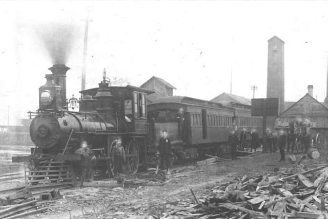
The Manistee & North Eastern Railroad was a short-line railroad operating in the northern Lower Michigan peninsula between Traverse City and Manistee, MI. Image: " Manistee & Northeastern engine No. 2 and the two coaches which inaugurated passenger service from this Buckley and Douglas mill site on January 6, 1889." (Manistee News) Additionally, the line had several branches, most notably from the mainline to Platte River Jct. (abandoned 1924) and Lake Leelanu, MI (abandoned 1944). It was incorporated in 1887, with the first operations beginning in January of 1889. At its peak, the mainline was over 62 miles in length. ( Right of Way ) Via the Leelanau Transit Company , it also traveled north to Northport, MI. Map of the M&NE Railroad and Branches, 1933. Via TrainWeb Like most of the rail lines in the region, it was built primarily to haul timber, but also carried passengers and other commodities. It was consolidated into the Chesapeake & Ohio in 1955, wit...

The Pre-Steam Railroads: Rail Transport Before the Steam Engine

Image
The word " prehistoric " refers to the time period before human records were kept, either by writing or artistic murals. While no exact date is agreed upon to which prehistory ended, it is generally accepted that human cultures began to document activities early in the Bronze Age, although culture began much earlier than that in the Neolithic period. You're probably thinking, what does this have to do with railroad history? I believe that rail transport history follows a similar progression with regard to its prehistory, although it is much simpler to understand exactly when railroad prehistory ended, right when steam took over. Railfans' interest in railroad history tends to began with the locomotive. In 1784, prototypes of steam locomotives were being developed, and  by 1802 , the  Coalbrookdale Locomotive  was created by  Richard Trevithick. In the next two decades, the concept of steam locomotion and the railroad itself would evolve, and England's...

The Macomb & Western Illinois Railway: One of Forgottonia's Forgotten Railways

Image
There are many abandoned railroad lines and forgotten railroad companies all across the United States, Canada, the United Kingdom, and indeed all across the world. Many of these companies  never even operated  a railroad for a single day. The reasons for abandonment of a particular stretch of railway could be a blog of its own, as each and every right of way has its own unique story, and economic factors which resulted in its demise. That said, the advent of paved roads and the trucking industry is a common factor in the abandonment of many tiny lines. " Railroad Short Train circa 1905" Image: WIU Archives & Special Collections Such is the case of the Macomb & Western Illinois Railway , known later in its life as the Macomb Industry & Litteton Railway, although one could also point to its poor construction and rural corridor as factors as well. Today we'll explore the relatively short life of this former line in the middle of  Forgottonia . ...

The Temporary US Highway: US Route 89T and Navajo Nation Route 20

Image
US Route 89T was the 46 mile long designation for Navajo Nation Route 20 after a 25 mile stretch of US-89 buckled due to a landslide in early 2013. From Indian Country Today, "The road collapse occurred in the early-morning hours of February 20, about 25 miles south of Page, Arizona, the state Department of Transportation said. The landslide “ripped through a section of US 89 along a mountain slope about 25 miles south of Page, buckling more than 150 feet of the roadway and tearing the pavement up in six-foot-high sections,” the Arizona Department of Transportation (ADOT) said in a statement on its website." The junction for US-89A, Navajo Route 20 and US-89T. (Image: US Route 89) As the Navajo had wanted to pave N20 for decades, and some design and environmental clearances had already been obtained, it took just 79 days to pave N20 in a project that might have otherwise taken more than a year.  "Immediately after the US 89 landslide, ADOT set an alternate route along...

The Ogden Canyon Conduit

Image
The Ogden Canyon Conduit is a 75-inch wood-stave pipe constructed by the Bureau of Reclamation with funds obtained from the National Industrial Recovery Act , as part of the New Deal. The Ogden Canyon Conduit is one of the few remaining examples of wood-stave conduit technology once used to transport water in Weber County, Utah. While much of the exterior is now concrete, this is what the wooden exterior looked like in the 1950's. View of wood stave pipe, looking east - Ogden Canyon Conduit, Ogden, Weber County, UT. Library of Congress. A section of the pipe was replaced in 2014. Ogden Canyon Conduit, Ogden, Weber County, UT

The 10 Most Pointless 3-digit Interstate Highways

Image
The Interstate Highway System is a marvel of engineering, even in spite of its cost, both economic and social. There are over 46,000 interstate miles in the US. Surely, not all of them are necessary. Some can even be considered pointless. A 1958 map of what was completed of the original interstate highway act, which has since been added upon in a significant way. Image: WTTW What makes a highway pointless, especially one built to the highest road standards in the world? It can be length, as many of these routes are only a mile or two in length, but it doesn't have to be. There are quite useful interstate highways that nonetheless very short (I-190 in Illinois and I-238 in California are good examples). Another qualification is the area they serve; many of these routes either don't connect to a significantly populated area, or don't facilitate downtown traffic. And while some of them most certainly do fulfill these criteria; they could do so without being labeled a...