The Abandoned Route 66 in McCook, IL
Route 66, the iconic "Main Street of America," weaves through the heart of the United States, connecting communities and embodying the spirit of adventure. However, not all sections of this historic highway have stood the test of time. While much of the former US 66 is drivable in one way or another, especially in Illinois, there are some parts are not.
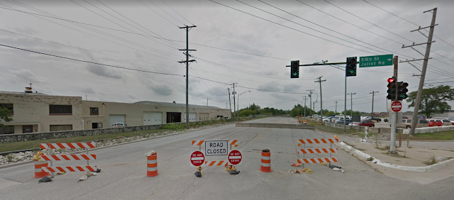
One of the first such roadblocks for would-be travelers heading from Chicago to Los Angeles via the Mother Road, now known as Joliet Road, comes just outside of Chicago in McCook, IL, where the former highway is closed between 55th St and East Ave, and has been for over two decades. (Link to the location on our Ghost Towns Map)
Image: Google Maps at 55th and Joliet Rd in McCook, IL |
The land that the quarry would eventually take over was part of Stinson Airport in the early days of Route 66, dating back to before 1930. (Abandoned Airports map).
 |
| 1938 USGS Aerial Imagery |
The quarrying on the south side of the road would force the airport's closure in 1958, when quarrying began on that site as well, leaving both sides of Joliet Road exposed.
In 1998, cracks began developing in the roadway, and rapidly grew into pavement buckling. IDOT was forced to close the road, making traffic have to detour onto arterial streets. On either side of the roadbed, Vulcan Materials Company owned the land and mined the area, in some cases hundreds of feet deep, causing the land under the road to give way.
 |
| Image: Rich Dinkela |
Today the road is still there, although Mother Nature is quickly taking it back, and the mine is still fully operational on both sides. Vulcan paid a $12 Million settlement after a 12 year legal battle, but did not admit fault in the road's closure.
At least on one occasion, the road has been used for filming, as it was in a short scene in the movie Source Code.
 |
| Image: The Movie District |
Despite the encroaching industrial landscape, nature has found a way to reclaim its territory. Overgrown vegetation peeks through cracks in the asphalt, and wildflowers bloom in the midst of forgotten pavement. The resilience of nature serves as a stark contrast to the man-made scars left by the quarries, creating a unique blend of beauty and decay. While the road today is now owned by Vulcan and off-limits, that hasn't stopped Rich Dinkela from taking a drone to assess the closure for himself, as you can see below.
A bit farther down the road, some more abandoned Route 66 history exists in Illinois as current Route 129. You can also check out Images of America: Route 66 in Illinois on Amazon (Clicking the link may earn the website a commission)
Thanks as always for reading!


605 ILCS 5/4-512
ReplyDeleteShould pay to fix it.
ReplyDeleteThey paid a settlement instead.
ReplyDeletehttps://www.chicagotribune.com/news/ct-xpm-2010-05-18-ct-met-vulcan-idot-settlement-20100518-story.html
Back in the 70s as part of a tour across the country, I bicycled Route 66 from Chicago to Oklahoma City. I drive through Dwight, Illinois every summer, and part of the original 66 with grass growing through it is still there.
ReplyDelete