Illinois Route 129 is hardly unique among State Routes in that it is a former alignment of US Route 66, specifically the 1940 realignment, but it is an interesting both for its time as The Mother Road, and a more modern case study in deteriorating infrastructure in this country, as is used to be much more robust than its current 4-mile alignment between I-55 and IL-113 in Braidwood.
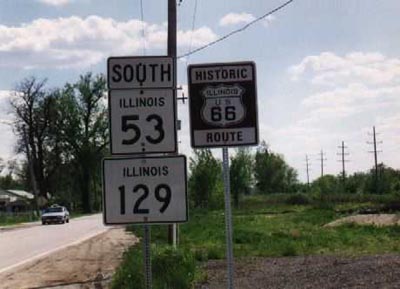
For those looking to traverse Route 66, however, you'll find many more roadside attractions on the adjacent Route 53, like the
Polk-a-Dot Drive In in Braidwood, or the
Gemini Giant in Wilmington.
 |
| Former bridge over railroad tracks at Braceville on IL-129 (Formerly US-66). Image: Library of Congress |
But today's blog is on IL-129. It's a product of the Interstate System, as it
gained its number in 1960 when US-66 was rerouted onto a new freeway slightly west of the 1940 realignment, in anticipation of what would become US-66's replacement, I-55, which is what it is today.
 |
| IL-129 shield from IL-113 in Braidwood. |
The original
US Route 66 more closely paralleled the Chicago & Alton Railroad, running south from Joliet on today's IL Route 53 on the east side of the tracks at Braidwood. The 1940 realignment brought the Mother Road west of the tracks, less than 200 feet from its original alignment, which was then labeled ALT-US-66.
 |
| At IL 129 & Coal City Rd, an abandoned fake piano from a 1950's advertisement for a music store based in Coal City. Image: Braidwood Historical Society. |
I've always thought that was a little strange to have two different alignments of the same road so close to each other, but I suppose it was preferable than having to deal with train traffic in those days.
 |
| Looking west from present-day IL-53 and IL-113 and the railroad tracks to what was a Sinclair Gas Station owned by the Rossi family. Image: Braidwood Historical Society. |
 |
| Here's the alignments on the 1940 Illinois Highway Map. Also note the existence of IL-113 N & S, now IL-113 and IL-102! |
Here's a Google Map of the entirety of IL-129 which shows the current and historical alignment of the route:
The two alignments would converge about 8 miles south at Gardner, which is where IL-129 used to end. However, this is where the crumbling infrastructure of 129 comes into play. A bowstring arch bridge on IL-129 built in its US 66 days to cross over railroad tracks was closed in 1995 when the structure was deemed insufficient.
The state decided that repairs of the bridge would be too costly, especially in light of the fact that Route 53 was 200 feet away. It was offered to preservation groups, but ultimately demolished in 2001, as it was too expensive to move. It's an example of a piece of infrastructure that didn't need to be preserved. But thankfully, we do have photos and
information on it.
When the bridge closed, the 129 designation was briefly moved over to Route 53 to Gardner, but was removed just a year later, since there was little benefit to giving a second number to an already well-known road, and 129 south of the bridge only diverged into Gardner. As Illinois prefers to end state routes at other routes, IL-129 was dropped south of IL-113, leaving much of the remaining pavement as an
unmarked highway, which it remains today.
 |
| IL 53/129 during their brief marriage as former US 66 alignments. Image: Richard Carlson |
In spite of now being unmarked, Route 129 is still on at least one sign just outside Gardner, where the road crossed Carbon Hill Rd.
However, the bridge over the tracks wasn't the only part of 129 closed as a result of structural deterioration. 129's interchange with I-55 is currently only a partial interchange, as it's currently only possible to get onto 129 from Northbound 55, since the southbound interchange
was demolished in 2011.
 |
| Bill Burmaster's photo of the now demolished interchange when it was first closed. |
The southbound to southbound movement was a flyover ramp over the northbound lanes. Not having this movement makes it
impossible to traverse Route 66 using I-55 and IL-129 going from Chicago. Followers of the Mother Road would have to exit at Joliet Rd and use the pre-1940 alignment.
The interchange is
planned to be rebuilt and reopened, however the project is currently linked to the shelved
Illiana Expressway project (for some reason), and thus no construction is imminent at this point. Thus, as presently constructed and signed, the route is 4 miles long, and doesn't even have a full interchange with one of its endpoints.
I liken Illinois 129 to a living fossil of infrastructure, which is why I think I find it so fascinating. The most interesting part of the Route is gone, and were it fully removed from the State Route system few would miss it, plus there are much longer unmarked sections of Route 66. It served as the Mother Road in between the original alignment and 66's conversion to a freeway, and thus doesn't have any of the interesting tourist traps of the 2 lane 66, nor the convenience of a freeway for long-distance travel.
I hope you enjoyed today's peek into part of Illinois' Route 66 history. Thanks for reading!


I always loved that bridge. When I was in HS I had a girlfriend that lived not far from the Rt 129 exit. You can actually access the north end of Old 129 by exiting at Lorenzo Rd. then continuing south on the Frontage Rd until reaching 129. There used to be a segment of original 66 pavement there. But other than a few reclaimed strip mines and liquor stores, there's not much to see (other than the Welcome To Braidwood - Home of Mayor Anton Cermak sign :-) )
ReplyDelete